China’s deep-sea mining fleet may also track US submarines (1)
By Elizabeth Claire Alberts, Kara Fox
● A Mongabay and CNN investigation found the eight Chinese state-owned ships that conduct deep-sea mining research in China’s mining areas allocated by the International Seabed Authority (ISA) actually spent little time in these exploration areas, while spending much of their remaining time operating in militarily strategic waters.
● Many of these vessels are linked to the Chinese Navy, have regularly called on military-connected ports, encroached on other countries’ coastal exclusive economic zones and turned off their AIS location beacons. While none of this proves the vessels serve military roles, it suggests the ships may serve dual-use purposes, having a strategic military role as well as a scientific one.
● With China positioning itself as a leader in deep-sea mining, the U.S. is accelerating its own push to access seabed areas and counter China’s dominance in critical mineral supply chains. The Cook Islands is one hotspot where U.S-China competition is intensifying.
● As competition heightens between China and the U.S., critics of the industry warn deep-sea mining could cause irreversible harm to marine ecosystems, raising fears that the environment could be the main casualty in this geopolitical rivalry.
This article was produced in partnership with CNN with support from the Pulitzer Center’s Ocean Reporting Network, where Elizabeth Claire Alberts was a fellow.
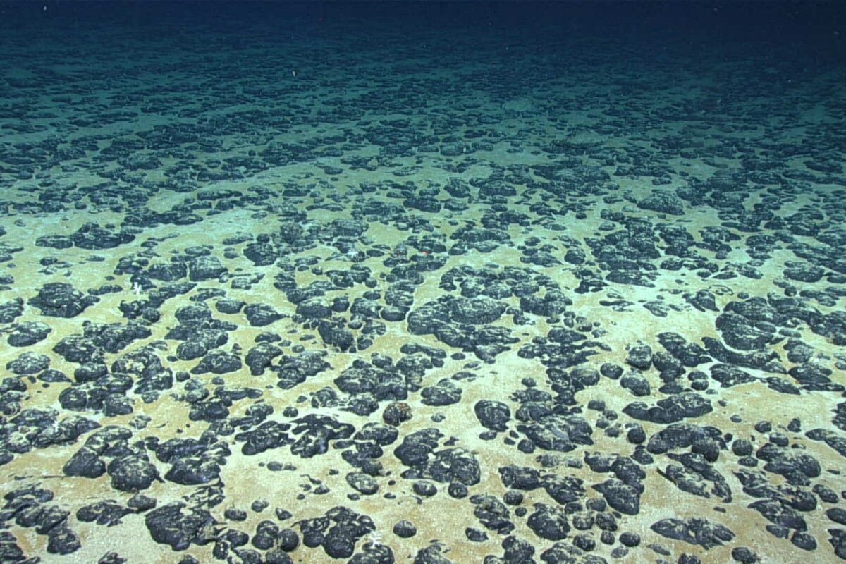
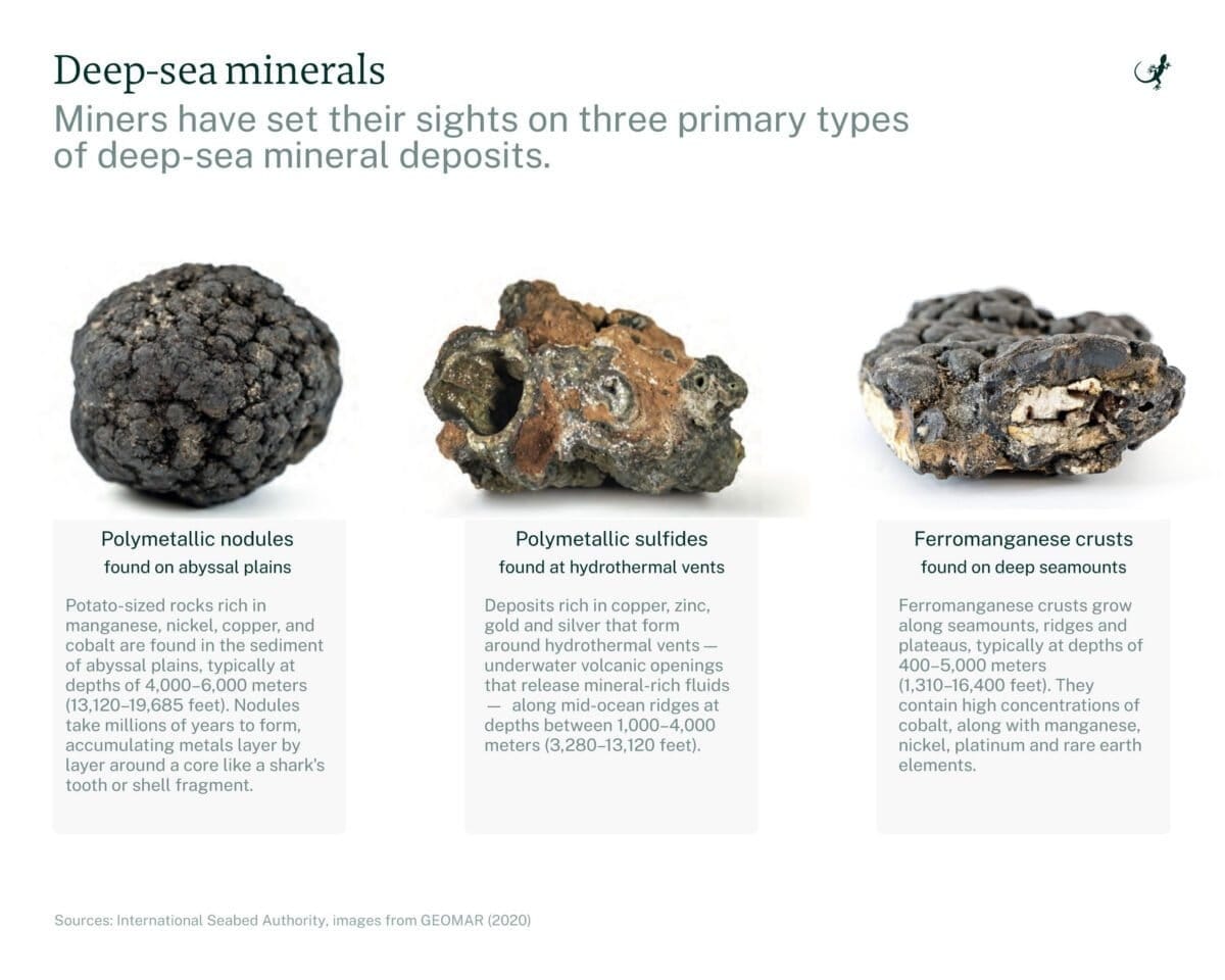
In June 2025, the Xiang Yang Hong 01, a chalky white vessel loaded with oceanographic equipment, cruised the Northwest Pacific until it reached a section of the seafloor rich in polymetallic nodules — potato-shaped rocks that contain valuable metals such as manganese, nickel, cobalt and copper. The ship zigzagged over the site, conducting research in the area miners could eventually exploit through deep-sea mining,a controversial industry that experts warn could irreparably harm marine ecosystems.
Since entering service in 2016, the Xiang Yang Hong 01, which translates as Facing the Red Sun 01, has gone on several deep-sea mining research expeditions in the Northwest Pacific. Yet, over the past five years, the Chinese state-owned ship spent far more time outside designated deep-sea mining exploration areas and logged extensive trips in militarily strategic waters. This vessel has also gone “dark” numerous times over the past five years, possibly disabling its automatic identification system (AIS) while operating in strategically sensitive ocean areas, according to New Zealand-based Starboard Maritime Intelligence.
“These gaps are significant,” Mark Douglas, an analyst for Starboard Maritime who is also in the New Zealand naval reserves, told Mongabay and CNN in an email. He said the Chinese ship “demonstrates a deliberate pattern of operating in sensitive areas, outside the view of traditional tracking systems.”
The result is a pattern that, experts say, shows the ship may be more interested in mining military intelligence than deep-sea minerals.
A spokesperson for China’s Ministry of Foreign Affairs did not address questions about the activities of the Xiang Yang Hong 01 or the potential military uses of its oceanographic research vessels. In a statement to Mongabay and CNN, the ministry said, “Within the framework of the International Seabed Authority (ISA), China conducts activities in deep-sea exploration, scientific research, and environmental protection, assisting a host of developing countries in effectively strengthening their deep-sea capacity building. This is in accordance with the provisions of the United Nations Convention on the Law of the Sea.” It added that China “highly values deep-sea environmental protection.”
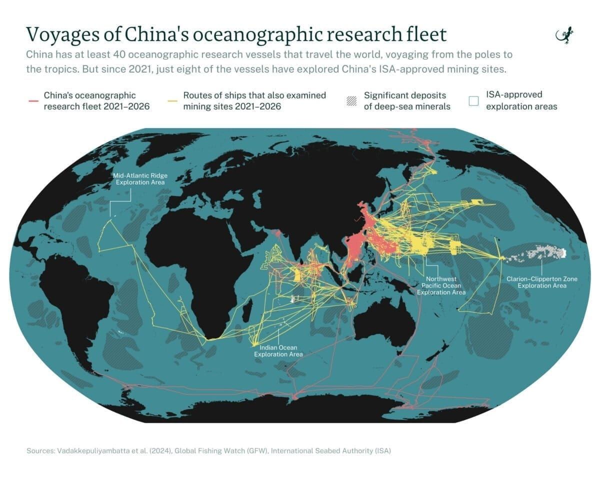
Mongabay and CNN tracked eight Chinese research vessels that have undertaken deep-sea mining exploratory missions over the past five years. During that period, the ships spent just around 6% of their total open water time in or near areas reserved by Chinese companies for deep-sea mining exploration, according to an analysis of data from MarineTraffic, a ship tracking provider, and the data platform Deep Sea Mining Watch.
The exploration areas are licensed by the ISA. Although the body has not yet finalized international regulations for deep-sea mining and commercial extraction has yet to begin, China has positioned itself as a global leader, holding five of the 31 exploration contracts issued by the ISA and serving as its largest financial contributor. The ISA told Mongabay and CNN by email that the “amount of contribution by a member State is not relevant to the number of the exploration contracts signed or sponsored by the member State.”
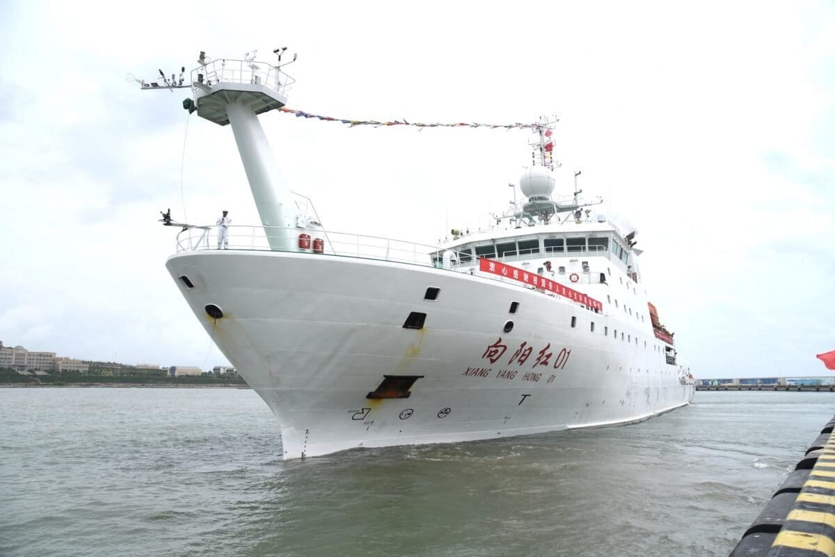
Photo taken on Aug. 10, 2019, shows Xiang Yang Hong 01, China’s elite scientific research ship, in Qingdao, east China’s Shandong province. Xiang Yang Hong 01 departed from Qingdao for the tenth Arctic expedition soon after. Image by Zhang Xudong/Xinhua/Alamy.
Many of the ships tracked by Mongabay and CNN are tied to state-affiliated entities with links to the Chinese Navy, known as the People’s Liberation Army Navy, and regularly call on military-connected ports. Some have also visited other countries’ exclusive economic zones, possibly to conduct surveillance, often without permission. Others have displayed patterns suggesting attempts to avoid detection, including “going dark” by failing to transmit their mandatory AIS signals that broadcast a vessel’s identity and position, possibly intentionally.
While none of this proves the vessels serve military roles, it suggests the ships may serve dual-use purposes, having a strategic military role as well as a scientific one. This thesis was supported by more than a dozen naval and military experts interviewed for this story. Mongabay and CNN reached out to multiple Chinese agencies and institutions, but none responded to questions about dual-use activities by China’s oceanographic research vessels.
“They want to know what’s going on at the bottom of the sea, where U.S. submarines might go, where their submarines might go, where other submarines might go,” Raymond Powell, a retired U.S. Air Force colonel and executive director of SeaLight, a nonprofit that focuses mainly on China’s maritime military activities, told Mongabay and CNN. “Mapping the seafloor in those places is going to be of intense interest to them.”
These alleged dual-purpose vessel missions appear to align with China’s broader pursuit of “maritime power” — a goal Chinese leader Xi Jinping first articulated in 2012, shortly after taking office, and reiterated over the years. Some analysts say China views the deep seabed, and the exploitation of its minerals, as its next frontier. In response, the U.S. is rushing to mine the deep seabed, with a stated goal of countering China’s dominance in the sector. The U.S. is backing up the move with a $12 billion investment fund to spur mining and boost the nation’s hold on critical minerals.
Alexander Gray, who served in the first administration of U.S. President Donald Trump as a deputy assistant to the president and chief of staff of the White House National Security Council, said the U.S. government has “a very real concern” about the potential dual uses of China’s research vessels. While previous administrations have been worried about these developments, he said the Trump administration is particularly focused on them.
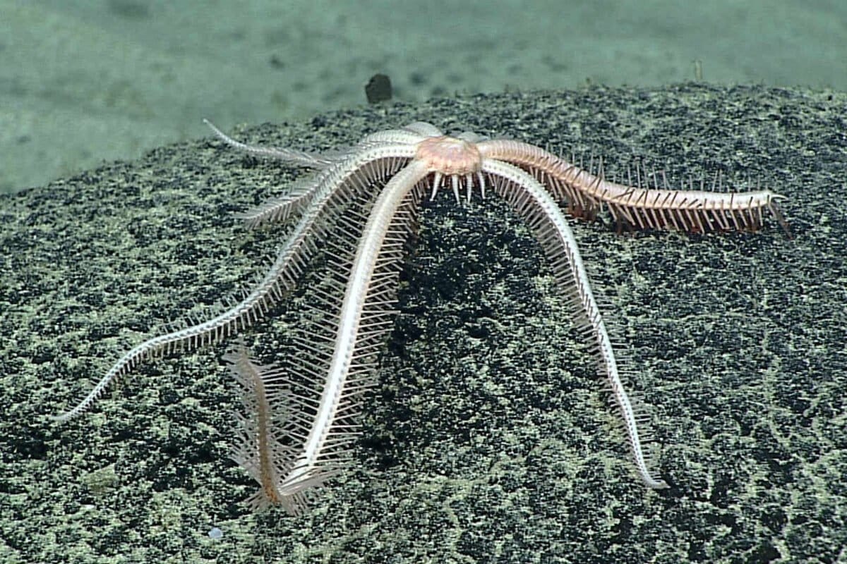
A Brisingid starfish on rock surface with botryoidal manganese nodules. Image by NOAA/OAR/OER, 2016 Deepwater Exploration of the Marianas, Leg 3.
Gray told Mongabay and CNN that the U.S. government is also concerned about China’s attempt to monopolize critical minerals.
“China [is] using critical minerals as a tool of economic coercion against the United States,” Gray said, adding that the U.S. should “diversify supply through deep-sea mining” to generate “resilience” to withstand China’s actions. “That, I think, very much justifies this speeding forward on this development,” he said.
The U.S. Department of State did not respond to questions seeking further detail on how competition with China is influencing the United States’ pursuit of deep-sea mining. China’s Ministry of Foreign Affairs also did not respond directly to questions about U.S.-China competition for deep-sea minerals.
As both China and the U.S. pursue deep-sea mining, critics of the industry, including government officials, scientists and environmentalists, warn the marine environment could be the loser in this race to the bottom of the ocean.
China’s growing influence in the ocean
To examine China’s deep-sea mining activities, Mongabay and CNN, with the support of the Pulitzer Center, tracked eight Chinese vessels that have undertaken deep-sea mining exploratory missions during the five years, from January 2021 to January 2026. These are the only Chinese research ships that have visited China’s ISA-designated mining areas since 2021, the period most relevant to current geopolitical tensions and developments in deep-sea mining.
There are at least 32 additional vessels in China’s oceanographic research fleet that have traveled across the global ocean, from the poles to the tropics, according to the China Maritime Studies Institute, a research center at the U.S. Naval War College in Rhode Island. The experts Mongabay and CNN interviewed for this story say this broader oceanographic fleet not only studies oceanic phenomena but also undertakes missions that serve China’s military and strategic objectives. This research fleet is considered to be the largest in the world, although other countries, such as the U.S., also have sizable research fleets.
Most of the ships in China’s research fleet are owned and operated by state agencies, including the Ministry of Natural Resources. All rely on state funding, which includes initiatives that focus on deep-sea exploration, minerals and Chinese national security.
While China’s research fleet has traversed the world’s oceans, conducting bathymetric surveys to map the seafloor, China has contributed relatively little data to the public. Chinese organizations and research institutions contributed 41 data sets to a public data sharing effort on the world’s seas known as the General Bathymetric Chart of the Oceans (GEBCO), according to Pegah Souri, the head of external relations of Seabed 2030, a collaborative project between GEBCO and The Nippon Foundation. This accounts for roughly 0.7% of the total contributions to the global seabed mapping initiative. China’s Ministry of Foreign Affairs did not respond to questions about its contributions.
The locations analyzed for this story include China’s five areas licensed to three Chinese state-controlled entities: China Minmetals Corporation, Beijing Pioneer Hi-Tech Development Corporation Ltd. and China Ocean Mineral Resources Research and Development Association (COMRA). These five licensed areas give China more ISA contracts than any other member state, covering approximately 225,000 square kilometers (86,900 square miles), roughly three times the size of Ireland.
The analysis also includes a roughly 74,000-km2 (28,500-mi2) reserve area in the Pacific. Beijing Pioneer was required to conduct surveys and submit the resulting data to the ISA in 2018. The following year, in 2019, it gave this reserve area to the ISA to benefit developing nations in the future. But despite the transfer, Chinese vessels have remained active in and around this area, even though it is no longer required to submit data.
Over a five-year period, these eight Chinese ships spent a combined 814 days operating in or near these areas licensed or reserved for exploration by the ISA.
Within these areas, the vessels traveled a combined 102,000 km (63,400 miles) — more than twice the circumference of the Earth. News coverage and corporate documents confirm these ships were conducting deep-sea mining-related research while visiting these ISA areas, including collecting samples of sediment and organisms. COMRA, Beijing Pioneer and China Minmetals did not respond to questions about the scope of their research.
Other countries and companies hold an additional 26 exploration contracts covering a combined 1.2 million km2 (almost 470,000 mi2). There are also 890,000 km2 (nearly 345,000-mi2) that the ISA keeps on reserve for possible future exploitation by developing countries.
In the Clarion-Clipperton Zone (CCZ), a region about as wide as the continental United States, located between Hawaii and Mexico and known to harbor vast quantities of nodules, the ISA established “areas of particular environmental interest,” where no mining can take place. They add up to about 1.9 million km2 (760,000 mi2). Separately, the U.S. has issued an exploration license to defense company Lockheed Martin for a total of 232,000 km2 (90,000 mi2) in the CCZ, using the authority of a 1980 law known as the Deep Seabed Hard Mineral Resources Act (DSHMRA), which established a legal framework for U.S. citizens to pursue deep-sea mining activities in international waters. Over the past year, other companies have announced that they have applied for similar licenses.
Elizabeth Claire Alberts is a senior staff writer for Mongabay and was a 2024-25 fellow with the Pulitzer Center’s Ocean Reporting Network. Find her on Bluesky and LinkedIn.
Kara Fox is a senior reporter at CNN International and a guest contributor to the Pulitzer Center.
Yong Xiong, Lou Robinson and Joyce Jiang of CNN contributed to the reporting of this story. Kuang Keng Kuek Ser and Fernanda Buffa of the Pulitzer Center also contributed to the reporting of the story
Citations:
Jones, D. O., Arias, M. B., Van Audenhaege, L., Blackbird, S., Boolukos, C., Bribiesca-Contreras, G., … Glover, A. G. (2025). Long-term impact and biological recovery in a deep-sea mining track. Nature, 642(8066), 112-118. doi:10.1038/s41586-025-08921-3
Stewart, E. C., Wiklund, H., Neal, L., Bribiesca-Contreras, G., Drennan, R., Boolukos, C. M., … Glover, A. G. (2025). Impacts of an industrial deep-sea mining trial on macrofaunal biodiversity. Nature Ecology & Evolution. doi:10.1038/s41559-025-02911-4
Xiao, X., Zhao, W., Song, Z., Qi, Q., Wang, B., Zhu, J., … Liu, S. (2025). Microbial ecosystems and ecological driving forces in the deepest ocean sediments. Cell, 188(5), 1363-1377. doi:10.1016/j.cell.2024.12.036